Geoinformation and space technologies
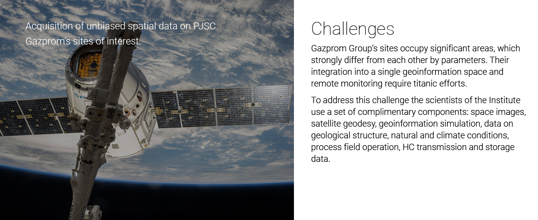
Opportunities
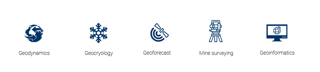
Geodynamic surveys:
- Simulation of rock movement and earth surface displacement caused by operation of HC fields;
- Identification of geodynamic hazard zones;
- Detection of hazardous natural processes by space images, hazard evaluation for existing and planned infrastructure, including classification of territories by complexity of construction conditions;
- Estimation of the current fault activity;
- Mining and geological substantiation of the need to construct geodynamic test sites.
Geocryologic surveys:
- Complexity assessment of the territory’s geocryologic conditions and hazards;
- Simulation and forecast of alternations in engineering and geocryologic conditions under man-caused impacts and climate changes, impact assessment on infrastructure facilities;
- Estimation of permafrost stability as a base for gas production and transmission facilities;
- Performance evaluation and development of integrated solutions on thermal permafrost stabilization at the base of gas well clusters.
Geoforecast surveys:
- Probability assessment to discover hydrocarbon fields in underexplored territories on the basis of airborne gravity and magnetic surveys, results of regional seismic exploration, satellite observations;
- Interpretation and analysis of seismic exploration data.
Mine surveying and geodesic support of subsurface use:
- Design of geodynamic test sites, including offshore fields to ensure industrial safety of subsurface management;
- Development and expert review of regulatory documents on mine surveying and geodesic support of HC production, storage and transmission;
- Development and expert review of mine survey works during HC production;
- Expert review and analysis of mine survey and geodesic observations over deformation processes of the earth crust, rock mass, buildings and structures.
Geoinformation technologies:
- Cartographic provision of operating activities in the process of HC production, storage and transmission;
- Development of geoinformation systems and geospatial databases;
- Geoinformation modeling;
- Development of algorithms for soft geodata processing.
Examples of comprehensive works
- Development and introduction of optimization technologies for geodynamic monitoring at the fields of PJSC Gazprom. This work resulted in estimation of earth crust displacements on all PJSC Gazprom fields and analysis of the state of geodynamic test sites. Upon the outcomes of the work, it was suggested to use new satellite radar interferometry and satellite geodesy technologies as basic observation methods applied at geodynamic test sites. This enabled to develop a unified methodological approach followed by introduction of changes in management philosophy to geodynamic monitoring systems functioning;
- Use of remote sensing to evaluate prospects to discover hydrocarbon deposits in the Zapadno-Kamchatsky licence area in the Sea of Okhotsk, Irbakansky, Yuzhno-Dzhunkunsky, Byuksky, Kubalakhsky, Bysykhtakhsky and Mukhtinsky areas of the Republic of Sakha (Yakutia), group of license areas and unallocated subsoil reserve fund around Kovyktinsky OGCF in Irkutsk region;
- Mining surveying and geodesic support, including mining and geological substantiations and development of investigation projects for the largest PJSC Gazprom’s onshore fields (Sobinskoye, Urengoyskoye, Tazovskoye, Zapolyarnoye, Bovanenkovskoye, Yuzhno-Russkoye) and offshore fields (Kirinskoye, Yuzhno-Kirinskoye, Shtokman);
- Identification and assessment of hazardous natural processes and phenomena on Severo- and Zapadno-Tambeyskoye, Malyginskoye, Tasijskoye, Bovanenkovskoye, Kharasaveyskoye, Kruzenshternskoye, Yuzhno-Russkoye, Yamburgskoye, Urengoyskoye, Kovyktinskoye, Chayandinskoye, Sobinskoye fields and on trunk pipelines Bovanenkovo-Ukhta, Urengoy-Pur-Pe and the Power of Siberia (Chayanda-Lensk section);
- Making cartographic part of the General Target Program and Development Layout for PJSC Gazprom process communication network;
- Field measurements of geocryological HC production conditions on the Yamal Peninsula;
- Development and validation of GIS Cartographic Model Atlas Guide “Comprehensive assessment of natural and man-made hazards and risks at pre-FEED stage of PJSC Gazprom’s projects”.
Advantages
- We use flexible and mainstream solutions in application, processing and analysis of geospatial data, space optic and radar images, geological and geophysical information that afford an opportunity to use open data and home software;
- We apply end-to-end solutions to address PJSC Gazprom R&D tasks in scheduling and implementation of survey control over UGSS facilities operation, and search for prospective HC deposits;
- We use cutting-edge process solutions in geodynamics, geocryology, geoforecast, geoinformatics, geodesy and mine surveying;
- We have multi-disciplinary competences;
- Scale of our works — all existing and future UGSS facilities of PJSC Gazprom.
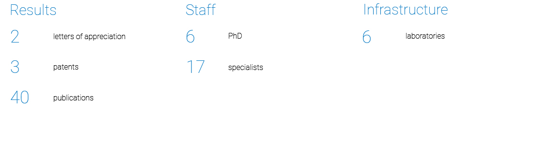
Statistics